logo
logo
keyboard_arrow_left home
Engineering Surveys Mining and Underground Surveys 3D Laser Scanning Mapping Consulting
What we do More
We are professionals with many years of experience in Sweden and the Czech Republic. We are not afraid of darkness, dampness, cold polar nights or strict legislation and regulations. We are aware of responsibility and at the same time dare to do really big and complex projects because we have education, experience and top equipment. And if we need consultations in related fields, we have someone to contact.
Networks+
Geodetic Control and Setting-out Networks

We create a setting-out network for you in a quality based on the requirements for accuracy and stability. Before initiating our works, we model the distribution of accuracy characteristics and the point configuration, and we suggest the most suitable measurement technology. Subsequently, we survey the network using properly selected equipment, level it and analyze the data. As with most important technical structures, the setting-out network also requires inspection and maintenance, which we are happy to arrange for you.

Setting out+
Setting out

Three-dimensional setting out is integral to the implementation of every construction, from a small house to a traffic tunnel. We offer comprehensive services, from design and analysis of accuracy, through the actual setting out, to inspection activities. From earthwork, through the establishment of constructions and concrete structures, to steel structures or installation of machinery; all using equipment and method suitable for the given type of work.

As-built Documentation+
As-built Documentation

We perform surveying of structures and their georeferencing for a wide range of purposes such as:

survey part of the built-as documentation, utility networks, and building passports
reverse engineering
surveying and calculation of geometric parameters of crane runways
preparation of documentation for the project
structural technical documentation, determination of floor areas
independent check surveying for important projects
custom-made solutions according to customer's wishes
Mass Calculations+
Mass Calculations

For the purposes of mass calculations, we use different measurement technology from rough surveying, e.g. earthworks using RTK GPS, through a total station, to accurate and detailed collection of data using a laser scanner. The method is chosen based on the surface type, scope of work, the size and shape of the area of interest and the accuracy requirements of the customer.

Monitoring+
Monitoring

Regular measurement of shifts and deformations is usually an integral part of large surface and subsurface construction works. In conjunction with the project of geotechnical monitoring, we propose the measurement technology, collection of data, their analysis, and final evaluation.

Top quality is often not easy to see at first glance in our field. It includes the analysis of the input parameters and the correct selection of the measurement technology while maintaining all the requirements for accuracy and security.
67°52'

is the latitude of the northernmost geodetic control point we have managed to stabilize
Networks+ Setting out+ As-built Documentation+ Mass Calculations+ Monitoring+ Inquirykeyboard_arrow_right

What we do

Geodetic Control and Setting-out Networks

We create a setting-out network for you in a quality based on the requirements for accuracy and stability. Before initiating our works, we model the distribution of accuracy characteristics and the point configuration, and we suggest the most suitable measurement technology. Subsequently, we survey the network using properly selected equipment, level it and analyze the data. As with most important technical structures, the setting-out network also requires inspection and maintenance, which we are happy to arrange for you.

Realization
clear
Setting out

Three-dimensional setting out is integral to the implementation of every construction, from a small house to a traffic tunnel. We offer comprehensive services, from design and analysis of accuracy, through the actual setting out, to inspection activities. From earthwork, through the establishment of constructions and concrete structures, to steel structures or installation of machinery; all using equipment and method suitable for the given type of work.

Realization
filter_center_focus Setting out, Linear Particle Accelerator, Lund, Sweden, 2018
clear
As-built Documentation

We perform surveying of structures and their georeferencing for a wide range of purposes such as:

survey part of the built-as documentation, utility networks, and building passports
reverse engineering
surveying and calculation of geometric parameters of crane runways
preparation of documentation for the project
structural technical documentation, determination of floor areas
independent check surveying for important projects
custom-made solutions according to customer's wishes
Realization
clear
Mass Calculations

For the purposes of mass calculations, we use different measurement technology from rough surveying, e.g. earthworks using RTK GPS, through a total station, to accurate and detailed collection of data using a laser scanner. The method is chosen based on the surface type, scope of work, the size and shape of the area of interest and the accuracy requirements of the customer.

Realization
clear
Monitoring

Regular measurement of shifts and deformations is usually an integral part of large surface and subsurface construction works. In conjunction with the project of geotechnical monitoring, we propose the measurement technology, collection of data, their analysis, and final evaluation.

Realization
clear
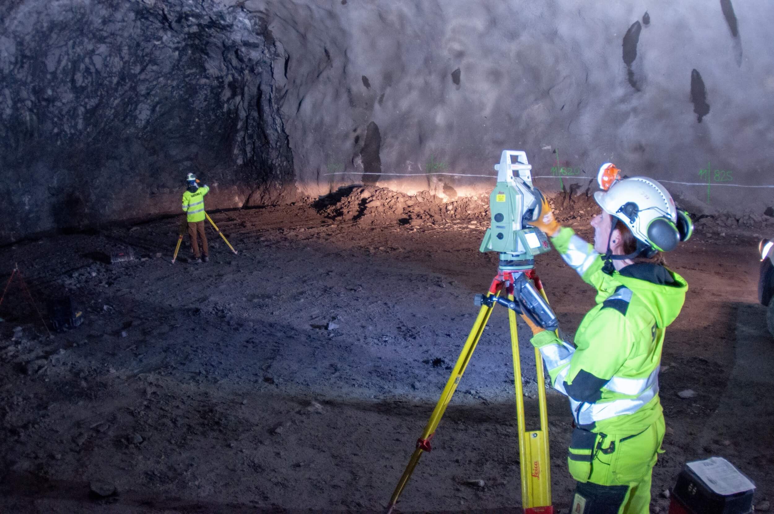
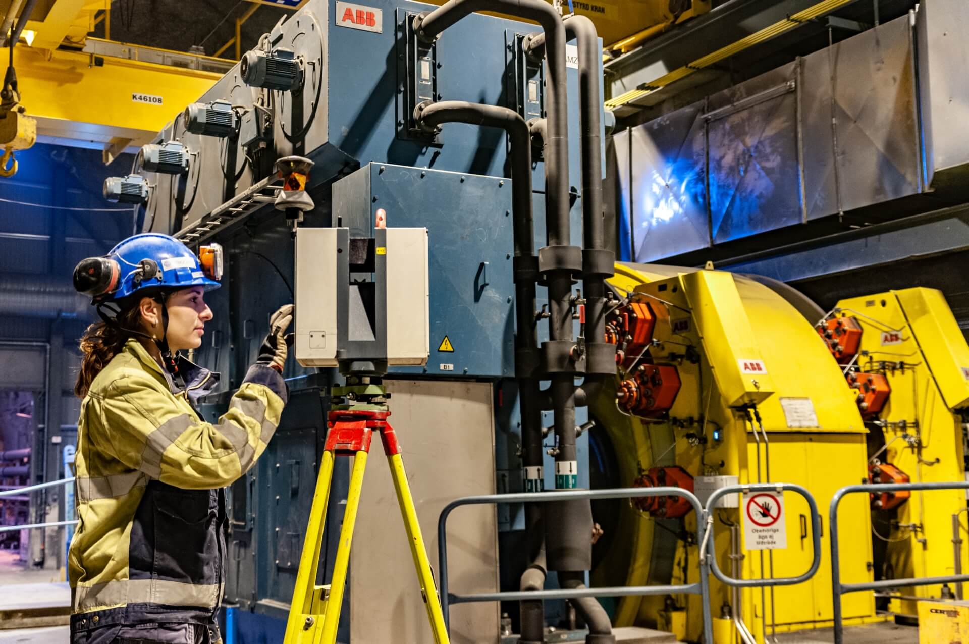
The implementation of projects of road, transport, water management and industrial buildings requires the services of survey engineering, from the phase of the project preparation, through the actual construction, to the handover of the building to the investor. We are happy to share our experience with you and provide you with services ranging from the creation of setting-out networks, through comprehensive survey support during the implementation, to the survey part of the as-built documentation.

Top quality is often not easy to see at first glance in our field. It includes the analysis of the input parameters and the correct selection of the measurement technology while maintaining all the requirements for accuracy and security.
67°52'

is the latitude of the northernmost geodetic control point we have managed to stabilize
Recommendation
Trigorn is a reliable and very professional organization that is an important partner/resource for us in our projects. They have a remarkable ability to select very suitable skillful staff for any type of survey project.keyboard_arrow_right
Lennart Gimring, Survey & Mapping Manager, AF Consult AF Consult
Realized projects
2015-2019
Kiruna, Sweden
Renovation of the LKAB mining shafts
2016-2019
Stockholm, Sweden
Förbifart tunnel bypass / Skärholmen / Stockholm
2016-2019
Lund, Sweden
Construction of a linear particle accelerator
2015-2019
LKAB Kiruna, Sweden
Installation of machinery as part of the renovation of mining machinery
2014-2018
Kiruna and Malmberget, Sveden
Long-term project for drilling ventilation shafts 2 m in diameter
2014-2018
Kiruna and Malmberget, Sweden
Long-term project for drilling energy and water distribution systems
2017-2018
Malmberget, Sweden
Project for the extension of the mine and the subsurface transport paths
2017-2018
Boliden, Sweden
Renovation of a mining shaft
2018
Aitik, Sweden
Construction of technological equipment for the processing of multi-metallic ore
2018
Boliden, Sweden
Construction of traffic tunnels in the Renströms and Kristineberg mines
2016-2018
Svappavaara, Sweden
Support for short-term planning of mining / Leveäniemi open-pit mine
2015-2017
Kiruna, Sweden
Opening of a new minie level in the LKAB Kiruna iron ore mine
2015-2016
Stockholm, Sweden
Construction of the Mall of Scandinavia business centre in Stockholm
2016
Mertainen, Sweden
Construction of a primary crusher for processing iron ore
2016
Martainen - Svappavaara, Sweden
Renovation and widening of the E10 road in the Svappavaara-Mertainen section
2015
Vassijaure, Sweden
Construction of snow barriers on the Kiruna-Narvik railway
2015
Kiruna, Sweden
Construction of a kindergarden in Bergkristallen, Kiruna
See all
Informace o cookies na této stránce
Soubory cookie používáme ke shromažďování a analýze informací pro vylepšení uživatelského zážitku a vhodného cílení reklamy. Více je zde.
OMEZIT
POVOLIT